What was used?
Identify the weapon category, reporting period, location and source. Keep historical incidents separate from new use.
RESIDUAL AFTERMATH / THE CONFLICT ATLAS
What does warfare do to a place? Choose a conflict to see the environmental finding, reported weapons and the evidence still missing.
Measured · Modeled · Reported · Unknown — read the evidence labels ↗
Search a place or choose a marker. The selected entry below explains what is reported, how we know, and what remains uncertain.
Loading conflict entries…
Background & satellite layers ↓Weapon coverage includes different reporting years. Open an entry for dates and sources.
Weapon filters cover 11 reviewed entries. They combine with region, topic and search. A match may describe past use or a remaining explosive hazard—not use today. New to the terms? Open the weapon guide ↓
Topics identify subjects discussed in the 10 source briefs. They do not confirm measured contamination or imply that other places are unaffected.
Questions search the 10 environmental briefs. Selecting one resets other filters; then narrow your results.
Read the evidence labels ↓Conflict situation Selected entry · uniform marker sizes
NASA Blue Marble — historical 2004 landscape context, not current conditions.
Markers locate selected conflict contexts, not incidents or measured contamination.
READ THE EVIDENCE
Loading coverage information…
The environmental briefs and weapon reports cover different places and periods. An unreviewed entry is a gap in this site’s coverage, not evidence of no damage.
Loading the last recorded source check…
Daily source checks are scheduled for around 8 a.m. America/Chicago time (schedule verified 29 October 2026). A scheduled check does not guarantee new findings or successful source verification. The run history below shows recorded checks; each update retains its own source dates and reporting period.
Read the coverage methods ↓The records could not load. Please reload this page, or open the data file.
OPTIONAL MAP CONTEXT
Change the background or add heat detections. These layers do not establish attacks or contamination.
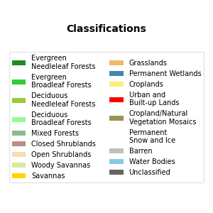
Classes: evergreen needleleaf and broadleaf forests; deciduous needleleaf and broadleaf forests; mixed forests; closed and open shrublands; woody savannas; savannas; grasslands; permanent wetlands; croplands; urban and built-up land; cropland/natural vegetation mosaics; snow and ice; barren land; and water.
Landscape: NASA Earth Observatory Blue Marble with topography and bathymetry, based on 2004 imagery. Land cover: NASA Terra/Aqua MODIS annual IGBP classification, 2024; this is a fixed reference year, not an automatically updated land-use survey. Satellite imagery: NASA Terra/MODIS corrected reflectance for the selected UTC date, defaulting to yesterday. A successful image request can still contain cloud cover or gaps. New imagery is requested when you change the date or map view.
These layers provide geographic context. They do not identify weapons, establish contamination, or attribute landscape changes to conflict. Conflict entries and heat detections have separate observation dates. Zoomed imagery is requested from NASA GIBS; saved overview images keep the landscape and land-cover options usable during service interruptions.
Blue Marble source · MODIS land-cover methods · NASA GIBS imagery service · Explore imagery in NASA Worldview ↗
LOOK CLOSER / ENVIRONMENTAL CASE STUDIES
Explore Gaza debris and vegetation, Sudan’s Sunut Forest, the Kakhovka dam breach and Lebanon’s Jiyeh oil spill. Compare each case with its own sources and reporting period.
Four selected cases · Snapshot: 27 October 2026 · Separate from automatic conflict updates. These are different indicators, not a damage ranking.
Open the full environmental dashboard ↗Page organization updated 28 October 2026. Ukraine energy and Gaza recovery source notes checked on that date. Other entry review dates are shown individually; this is not a live incident feed.
Approximate reference points, not front lines, affected-area boundaries, or incident locations. Nearby markers are separated with connector lines to their reference points. Drag to pan; use + / − to zoom. On phones, turn on Touch pan to drag the map; turn it off to scroll the page. No border or sovereignty claims are implied. Keyboard: Tab to a marker and press Enter to select; use arrow keys on the map to pan.
READ THE EVIDENCE
Labels describe how a finding is supported in the linked source. They are not confidence scores, independent verification or a ranking of study quality. Open each finding for its methods and limits.
A modeled result uses a model to represent or predict conditions. We do not relabel a general damage estimate as a contaminant model. No reviewed finding in this edition is labeled as a directly reproduced chemical measurement.
Back to the map filters ↑A PLAIN-LANGUAGE FIELD GUIDE
You should not need a military background to read a conflict report. Start with what a term describes, then check what the source actually establishes.
Aircraft carry weapons. Munitions are the ammunition used. Airstrikes and shelling describe attacks. UXO and remnants describe what remains. These labels answer different questions and can overlap.
Identify the weapon category, reporting period, location and source. Keep historical incidents separate from new use.
Investigate damaged water or power services, disturbed land, and explosive remnants. These are questions to test in each place.
Look for sampling, units, background comparisons and dates. Neither a strike report nor a weapon label establishes a pollution concentration.
General pathway basis: ICRC on explosive weapons, infrastructure disruption and remnants. The three-step framework is our reading guide, not a damage prediction.
In plain language: An aircraft with no pilot on board. UAV means uncrewed aerial vehicle. Some drones observe; some carry weapons; others are one-way munitions.
Read carefully: A drone is not automatically armed or autonomous. The label alone does not identify its payload.
ICRC · Drones in armed conflict ↗In plain language: Missiles and rockets are grouped here because sources use both terms. Missiles generally have guidance; rockets may be unguided or guided.
Read carefully: This is a browsing group, not one weapon type. Check the source for the specific system; not all missiles use rocket propulsion throughout flight.
ICRC · Explosive weapons ↗In plain language: Guns and mortars launch projectiles. Reports often describe their fire as shelling. This filter also includes tank fire.
Read carefully: Shelling identifies a kind of attack, not the exact shell or its contents.
ICRC · Explosive weapons ↗In plain language: Aerial bombs are dropped from aircraft. An airstrike is an attack from the air and may involve bombs or other weapons.
Read carefully: An airstrike report does not, by itself, identify the munition.
ICRC · Explosive weapons ↗In plain language: Explosive devices designed to activate when a person or vehicle is present, nearby or in contact.
Read carefully: A mine report may concern devices left from earlier fighting. It does not necessarily report new mine laying.
UN mine action standards · Glossary ↗In plain language: IED means improvised explosive device: an explosive device made or adapted outside standard ammunition manufacture.
Read carefully: Improvised does not mean harmless or simple. Some IEDs also meet the definition of a mine; categories can overlap.
UN mine action standards · Glossary ↗In plain language: A munition that releases smaller explosive submunitions. Some can fail to explode and remain hazardous.
Read carefully: Reported use and unexploded submunitions are different findings. A remnant does not establish a new attack.
Definition & reporting context ↗In plain language: White phosphorus is a substance used in some munitions for effects such as smoke. It can also cause severe burns and fires.
Read carefully: The substance name alone does not establish its purpose in an incident or automatically classify the munition as a chemical weapon.
Definition & reporting context ↗In plain language: Weapons that use the toxic properties of chemicals to harm people or animals.
Read carefully: An industrial chemical can be used as a weapon. Chemical pollution from a conventional strike is not, by itself, evidence of a chemical-weapon attack.
Definition & reporting context ↗In plain language: UXO means unexploded ordnance: explosive ammunition prepared for use or used but still unexploded. ERW means explosive remnants of war and includes UXO and abandoned explosive ordnance.
Read carefully: These terms describe remaining explosive hazards, not measured chemical pollution or the date of an attack.
UN mine action standards · Glossary ↗Plain-language summaries informed by the linked sources; terminology reviewed 25 October 2026. These are reading aids, not complete technical or legal definitions. “Find matching entries” clears other filters and searches the 11 reviewed weapon summaries.
COVERAGE / METHODS / LIMITATIONS
A situation is not a conflict count.
This first edition groups selected current conflict settings into geographic entries. Some entries combine several armed conflicts; Gaza and the West Bank appear separately within one wider conflict. The entry count is neither a global total nor a count of countries at war.
Entries were checked against public reporting on 21 October 2026. Sources include CFR’s Global Conflict Tracker, ACLED analysis, ICRC, ACAPS, humanitarian organizations and news reporting. Inclusion indicates a reported conflict situation or armed violence; it is not an independent legal classification under international humanitarian law. Haiti is explicitly labeled armed violence.
Coverage is incomplete. Lower-visibility conflicts and recent developments may be missing. Ceasefires can coexist with continued violence. Conflict entries are a manually maintained snapshot, not a live conflict-event feed. The optional satellite thermal overlay is fetched separately and does not update or validate conflict entries. The review date is not the date of every source or event; each entry describes its source period.
Ten entries have source-linked environmental briefs: Gaza, Ukraine, Sudan, Yemen, Myanmar, Lebanon, Syria, Iraq, Colombia and eastern DR Congo. Each distinguishes findings, evidence basis and interpretation limits. These are selected source summaries, not systematic reviews or independent field validation. Other entries have not yet received a literature review on this map. That does not mean environmental harm is absent. Neither a conflict marker nor a damage report establishes measured contamination, exposure or a contaminant fate state.
Eleven entries summarize broad weapon classes from selected public reports. Filters also include legacy hazards: landmines, improvised explosive devices (IEDs), unexploded ordnance (UXO) and other explosive remnants. Reporting periods vary. These are not complete arsenals or evidence that a weapon is being used today. Weapon categories do not establish measured contamination or identify a metal or chemical concentration.
For a wider inventory, consult Geneva Academy’s War WATCH and its methods and reporting period. Its published initial classification period ends June 2025. ACLED covers political violence more broadly; CFR selects situations relevant to U.S. interests. These sources use different scopes.
Land outlines: Natural Earth, public domain, 1:110m land. Reference points are editorial approximations. The map excludes Antarctica and does not display territorial boundaries.
Download the dated map records (JSON) ↓Notice a missing situation or source correction? Send a source or correction ↗
NEXT: CONNECT THE CASES